02 August, 2018
Space imagery helps tackle Scotland’s wildfires

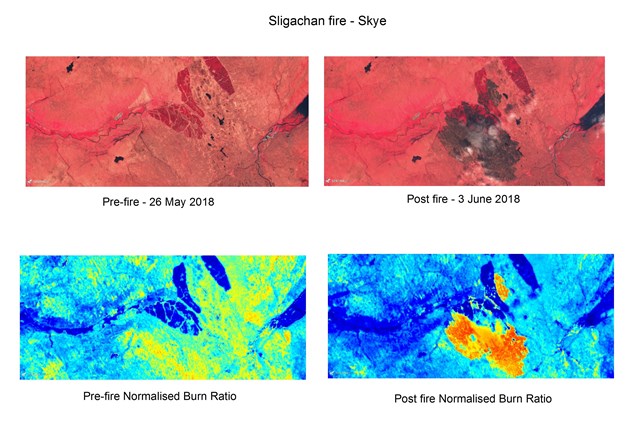
Breakthroughs with satellite technology are helping Scottish Natural Heritage (SNH) to map and understand the devastating effects of wildfires in Scotland.
SNH’s GIS Services Manager Lachlan Renwick said: “Using European Space Agency's Copernicus programme - the most ambitious Earth Observation programme to date - is a game changer for us. Getting good quality imagery in Scotland, and particularly cloud-free photography has been an issue. But now we have two satellites coming over on a regular basis, giving us imagery every two to three days, and at a higher resolution than previously available. It’s a huge breakthrough in mapping the extent and severity of burnt areas especially where they have impacted upon protected sites.”
Wildfires can have a devastating effect on wildlife and natural habitats. In spring 2018 there were several significant fires on Rum and in northern Sutherland, and more recently a series of wildfires in the west including Skye and Torridon. The data from orbit is processed to show how much light is reflected at different frequencies, showing in detail the extent of fire damage on plants and the soil beneath.
Dr Graham Sullivan, uplands adviser with Scottish Natural Heritage said: “Healthy peatlands hold onto carbon, preventing its release into the atmosphere to trap heat from the sun. Wildfires burn off carbon that's been stored for thousands of years, and by burning the plants incorporated into the peat that store carbon, wildfire reduces the bog’s ability to store more.
"Satellite imagery can play a vital part when we’re working these habitats to recover. Having information on a wildfire’s severity helps us target actions that can aid recovery of vegetation. This can include something as seemingly simple as deciding whether and when sheep are allowed to graze will dictate if heather recovers or purple moor grass takes over.”
SNH is currently in the initial stages of understanding the potential of satellite imagery, and are exploring its potential for mapping the locations of Scotland’s wildlife, and any changes over time.
Contact information
- Name
- SNH Media
- snhmedia@snh.gov.uk
Notes to editors
PHOTO CREDITS: All photos (c)SNH; data credits included on image.
Scottish Natural Heritage is the government's adviser on all aspects of nature and landscape across Scotland. Our role is to help everyone understand, value and enjoy Scotland's nature now and in the future. For more information, visit our website at www.nature.scot. SNH is also on Twitter at http://twitter.com/nature_scot
NatureScot is Scotland's nature agency. We work to enhance our natural environment in Scotland and inspire everyone to care more about it. Our priority is a nature-rich future for Scotland and an effective response to the climate emergency. For more information, visit our website at www.nature.scot or follow us on X at https://x.com/NatureScot
’S e NatureScot buidheann nàdair na h-Alba. Bidh sinn a’ neartachadh àrainneachd na h-Alba agus a’ brosnachadh dhaoine gu barrachd suim a chur ann an nàdar. Tha e mar phrìomhachas againn gum bi nàdar na h-Alba beairteach agus gun dèilig sinn gu h-èifeachdach le èiginn na gnàth-shìde. Tha an tuilleadh fiosrachaidh aig www.nature.scot no air X aig https://x.com/NatureScot


