09 October, 2018
Mapping breakthrough with benefits for people and nature
The wildlife and landscape of Scotland’s wildest and most remote islands, moorland and mountain ranges are set to be understood as never before, through ground breaking new mapping technology that can help us to tackle climate change and manage our upland habitats.
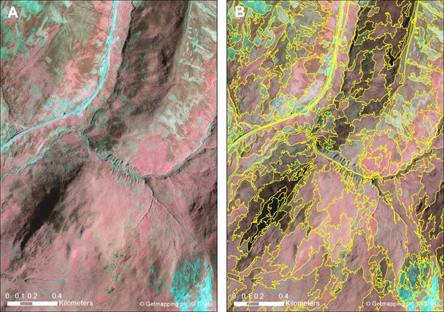
The innovative method for mapping our upland habitats is being pioneered in the UK by Scottish Natural Heritage (SNH). It uses a technique developed in Sweden known as ‘stereo colour infrared (sCIR) aerial photo interpretation (API), which uses imagery taken from aeroplanes.
Sally Thomas, SNH’s Director of People & Nature, said: “This technology really is a game changer for our work in some of the remotest parts of Scotland. Healthy peatland is a key factor in tackling climate change. It holds onto carbon, preventing its release into the atmosphere to trap heat from the sun. This cutting edge technique means we can identify prime locations for our peatland restoration work. It can also help us to manage woodland expansion, and it’s great news for protecting our diverse upland habitats: as well as the widespread heaths and bogs there are many small, fragmented and internationally rare habitats, such as important calcareous grasslands and juniper scrub.”
Using high resolution imagery with infrared information reveals colour and texture differences in vegetation. A range of indicators reveal detailed habitat such as blanket bog, wet grasslands and bracken. SNH has developed this technique for upland habitats and tested the method on a wide range of habitat types.
The report of the successful pilot, which took place over two 100 km2 areas in the Cairngorms and near Beinn Eighe National Nature Reserve, was announced at a major conference on geographic mapping and analysis in Perth today.
Kath Leys, Ecosystems & Biodiversity Manager for SNH said: “There are around three million hectares of upland habitat still to be mapped – about one third of Scotland. Using current field based methods this would take a large team of surveyors many years, due to the short season when they can get out on the ground in these remote areas, whereas this more desk based approach can continue throughout the year. Our pilot of this cutting-edge technique has delivered accurate results much more quickly and at less than half the cost.”
SNH is leading a multi-partner project to produce a comprehensive Habitat Map of Scotland (HabMoS). Partners in the HabMoS project are currently considering the next steps to secure funding to complete the upland mapping work.
Ends
Notes to editors
- The HabMoS project is a major contribution to the Scottish Government’s 2020 Challenge for Biodiversity and, together with the UK SeaMap, will in time provide a complete picture of all of Scotland’s habitats.
- 22 of the 52 Scottish terrestrial habitats protected under the EC Habitats Directive are found in upland areas.
- The HabMoS is available on SEWeb at https://www.environment.gov.scot/our-environment/habitats-and-species/habitat-map-of-scotland/ and on SNH website at https://www.nature.scot/landscapes-and-habitats/habitat-map-scotland.
- SNH Commissioned Research Report 983: Habitat Map of Scotland upland mapping pilot: developing a method to map upland habitats using stereo colour near-infrared aerial imagery is available on www.nature.scot
- The upland mapping pilot project used a stereo colour Infra-Red (sCIR) aerial imagery interpretation (API) method to identify habitats, which involves some field reconnaissance visits, but is mostly desk based; the stereo and IR information enhance the imagery to give greater colour differentiation and 3D depth. Polygon boundaries are created through an automated computer process that is then refined manually by the mapping officer as part of the interpretation. Habitat interpretation indicators for each upland habitat have been developed by SNH as part of the method.
- This is the first time that Habitat Interpretation Indicators have been developed for upland habitats, for use with the sCIR API method. This is an important step in developing a standard for remote sensing habitat surveying. The Habitat Interpretation Indicators are given in Annex 2 of the report.
- The method continues to be developed as part of the Collaborative Action for the Natura Network (CANN) project, a collaborative project between Scotland Northern Ireland and Southern Ireland
- The pilot project has taken forward the method previously described in the SNH Research Report 767 Trial mapping of upland Annex I and EUNIS habitats using stereo colour near-infrared aerial imagery published in February 2017.
Contact information
- Name
- Dominic Shann
- Job Title
- Media Relations Officer
- Telephone
- 01463 725157
- dominic.shann@nature.scot
NatureScot is Scotland's nature agency. Responding to the twin crises of biodiversity loss and climate change, we work to protect and restore nature by inspiring everyone to value our natural world. Our goal is a nature-rich, net-zero future for Scotland. For more information, visit our website at www.nature.scot
'S e buidheann nàdair na h-Alba a th’ ann an NàdarAlba. Bidh sinn a’ gleidheadh agus a’ slànachadh nàdar le bhith a’ brosnachadh a h-uile duine gu spèis a chur air an t-saoghal nàdarra againn, agus sinn a’ freagairt air an dà chùis-èiginn de chall bith-iomadachd ’s atharrachadh na gnàth-shìde. ’S e ar n-amas nàdar beairteach ’s cothromachadh carboin do dh’Alba. Airson an tuilleadh fiosrachaidh, thoiribh sùil air an làraich-lìn againn aig www.nature.scot

